Nagarkot
Ridge village 32 km east of Kathmandu at 2175 m with Himalayan views from Annapurna to Everest on clear days, pine forests, and trails to Bhaktapur.
Before you go
NagarkotBest months
Suggested days
Daily budget
Airport
NPR
Language
What is this place?
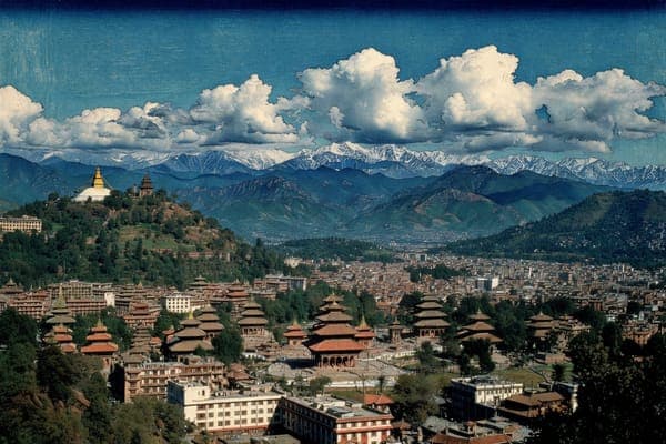
Nagarkot is a hill station on a forested ridge in Bhaktapur District, Nepal, 32 km east of Kathmandu at 2,175 metres. The air cools and carries pine scent while the land falls toward the valley floor. It serves as both a viewpoint for the Himalaya and a trailhead for forest walks. On clear mornings the sightline covers eight ranges from the Annapurna massif west to Everest east.
Why does it matter?
It supplies one of the closest places to see Everest and multiple ranges without a long trek. The royal watchtower has drawn Nepal's former rulers for the same panorama. The ridge links directly to Bhaktapur via a marked trail, mixing mountain air, rhododendron forest, terraced farmland, and Tamang and Newar village life in a compact area.
How to get there?
Kathmandu airport (KTM) lies 32 km west. Taxis cover the distance in 1.5 hours. Buses from Bhaktapur Bus Park take 45 minutes and cost less. The ridge settlement is compact. Most guesthouses sit within a 15-minute walk of the main viewpoint. The trail to Bhaktapur requires 4 to 5 hours downhill.
What you do here?
Sunrise viewpoints, forest loops, ridge trails
Wake before dawn for sunrise from the ridge or watchtower. Light moves across the peaks from pink to gold while lower hills emerge. Walk the Nagarkot Panoramic Trail, a 2-to-3-hour loop through pine and rhododendron forest and farmland. Hike downhill to Bhaktapur in 4 to 5 hours through villages and fields. Return at dusk to watch the valley floor glow amber below the darkening ranges. Visit the old watchtower for its elevated platform.
Where to stay?
Ridge guesthouses and hotels facing the ranges
Most options cluster near the watchtower at the highest point or scatter along the trails. Family-run guesthouses offer simple rooms, home cooking, and terraces positioned for the views. Higher placements on the ridge give clearer sightlines to the peaks. Properties farther down the slope sit closer to forest paths and village rhythms.
Where to eat?
Guesthouse terraces, Nepali plates, valley outlook
How long?
Two nights suffice for sunset, sunrise, and one trail. Three nights allow the hike to Bhaktapur plus time to explore that town before return to Kathmandu. Arrive by mid-afternoon to settle before dusk colours the ranges.
Who else does this?
What's nearby?
What's nearby?
6Nepal's preserved medieval city in the Kathmandu Valley, red-brick squares, five-tiered pagodas, active pottery yards, Newari crafts and king curd.
Nepal's capital at 1,400 m in the Himalayan foothills, Kathmandu Valley UNESCO World Heritage with Durbar Squares, Boudhanath stupa, Pashupatinath temple, and gateway to Everest and Annapurna treks.
Nepal's Newari craft city in the Kathmandu Valley with Durbar Square temples from 1636, the Patan Museum, and active bronze workshops in Mangal Bazaar.
Nepal's UNESCO World Heritage national park in the Terai lowlands, one-horned rhinos, Bengal tigers, gharial crocodiles, and Tharu culture along the Rapti River.
Nepal's lakeside gateway to the Annapurna range on Phewa Lake, Sarangkot sunrises, paragliding, Tal Barahi Temple, and trailhead for the Annapurna Circuit and Base Camp treks.
Nepal's UNESCO World Heritage site marking the Buddha's birthplace on the Terai plains - the Maya Devi Temple, 249 BCE Ashoka Pillar, and monasteries from 20 countries.
What's the catch?
Before you go
- Season: Oct-Mar for clearest views
- Budget: $$ ($50-120/day per person)
- Visa: On-arrival options for most passports
- Currency: NPR, USD widely accepted in hotels
- Language: Nepali, English common in guesthouses
- Power: Types C and D, 230V
- Altitude: 2175 m, drink extra water on arrival
- Views: Arrive evening before for sunrise
- Transport: Taxi preferred over bus for comfort